Sign up for email updates
Receive email updates from Community Transit about the Swift Gold Line project, including opportunities to give input.
Welcome
Welcome to Community Transit’s online open house for the Swift Gold Line project. Here you can:
- Click the Watch a video! button to get an overview of the project (10 minutes)
- Use the tabs below to learn more about the project, proposed station locations, and options for where Swift buses would travel on the roadway
- Sign
up for email or text updates about the project
Thank you to everyone who shared their input on the proposed station locations and bus lane options. We received more than 550 survey responses and comments and talked with nearly 600 people out in the community! We heard:
- Support for the Swift Gold Line project overall, routing through Downtown Everett, and proposed use of center-running transit-only lanes
- Requests to study impacts to parking, businesses, and removal of the two-way center-turn lane with center-running transit-only lanes
- Enthusiasm for improvements to sidewalks, crosswalks, and the flow of traffic
- Concerns about safety and security on Swift buses, at the stations, and for nearby neighborhoods
Learn more about the engagement efforts and research conducted during Phase 2 in the Swift Gold Line Phase 2 Engagement Summary.
All about Swift Gold Line
Want to learn more?
Click on the tabs below to explore more information and ask general questions.
- About: Get an overview of Swift Gold Line.
- Video: Watch a special Swift Gold Line episode of That Transit Show to see an interview with the BRT Manager, Morgan McGrath, and details about center-running, dedicated bus lanes.
- Benefits: Discover how bus rapid transit (BRT) helps drivers and transit riders alike get around more easily.
- Stations: Understand the Swift Gold Line route and proposed station locations, as well as how station locations were evaluated.
- BRT Design: Explore options we've studied for designing the project and how dedicated center lanes for BRT in high-traffic areas of Everett and Marysville would work to isolate buses from other lanes of traffic.
- Q&A: Still have a question for the project team? Ask it here.
About
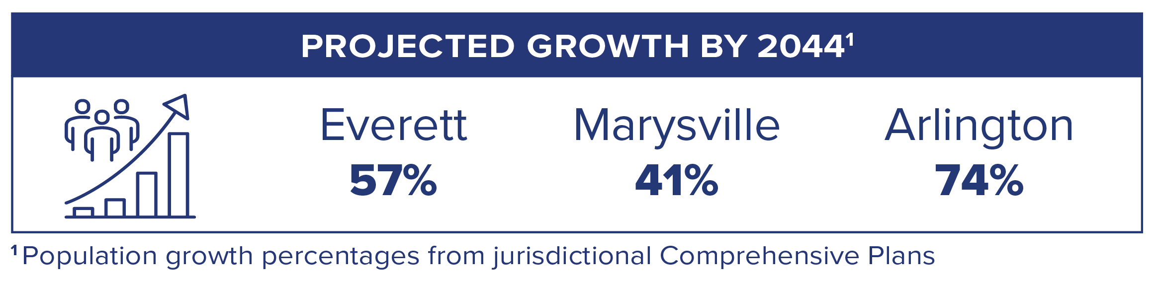
Community Transit is planning for rapid population growth and increasing traffic with a new investment to move more people in Everett, Marysville, and Arlington. Swift Gold Line will extend the popular Swift bus rapid transit (BRT) system to north Snohomish County, expanding transit capacity while maintaining capacity for cars. Expanding BRT offers a solution to increasing population and traffic that will benefit everyone, including cars, buses, and pedestrians.
Swift Gold Line brings you:
 A 15-mile bus rapid transit line between Everett, Marysville, and Arlington.
Fast, frequent, and reliable service with buses every 10 minutes.
More choices for traveling in the community and the region.
An investment to move more people through the corridor while maintaining capacity for cars.
FAQs
Swift is Community Transit’s bus rapid transit (BRT) service. Everything about Swift – the buses, stations, routes, and the way you pay – makes getting around Snohomish County faster and easier.
Swift connects you with regional transit options, getting you farther faster. Swift buses arrive every 10 minutes on weekdays, and every 15-20 minutes during early mornings, evenings, and weekends, meaning you do not even need to check a schedule. Swift meets community needs for transportation options in the corridor by promoting transit ridership. Community Transit’s Swift Blue, Swift Green, and Swift Orange lines have the most riders in our system.
Currently, you can ride:
- Swift Blue Line along Hwy 99 between Shoreline North/185th light rail station and Everett Station.
- Swift Green Line along Hwy 527, 128th St SW, and Airport Rd between Canyon Park Park & Ride and Seaway Transit Center.
- Swift Orange Line along the Bothell-Everett Hwy, 164th St SE, 36th Ave W, Alderwood Mall Blvd, and 196th St SW between McCollum Park Park & Ride and Edmonds College.
Community Transit is expanding our Swift network. In addition to Swift Gold Line, we are planning for the Swift Green Line Extension to add up to seven new pairs of stations between Canyon Park Park & Ride and UW Bothell/Cascadia College. We expect to open the Swift Green Line Extension in 2030.
Existing Swift lines travel in the rightmost lane of traffic. These lines use a combination of transit signal priority (TSP) and business access and transit (BAT) lanes to keep the buses running swiftly.
- TSP adjusts the timing of a traffic signals to reduce the amount of time transit vehicles wait at a red light. The signal green time is extended as the bus approaches the intersection. Transit signal priority can also be combined with a queue jump lane to allow buses to get an early green signal and in front other traffic. Sometimes, this also looks like a separate light for buses that turns green first, so that they can get ahead of traffic.
- BAT lanes require all vehicles to turn right, except for buses. Vehicles other than transit may not continue through an intersection in this lane. BAT lanes can be found at the curbside/rightmost lane of traffic. BAT lanes currently exist in some areas on Swift Blue and Swift Green lines.
The anticipated cost of the project is $189M-$199M. The project requires no additional local funding or new taxes. The project will be funded by state and federal grants (Capital Investment Grants Program) and revenue from the existing Community Transit sales tax rate. The Swift Gold Line project recently received approval from the Federal Transit Administration to enter the project development phase for the Capital Investment Grants Program, which is a crucial step in making this project a reality.
Documents
Video
Watch a special Swift Gold Line episode of That Transit Show to see an interview with the BRT Manager, Morgan McGrath, and details about center-running, dedicated bus lanes.
Benefits
Swift Gold Line joins three existing BRT lines: Swift Blue Line (Shoreline – Everett), Swift Green Line (Bothell – Seaway Transit Center), and Swift Orange Line (Edmonds College – Mill Creek).
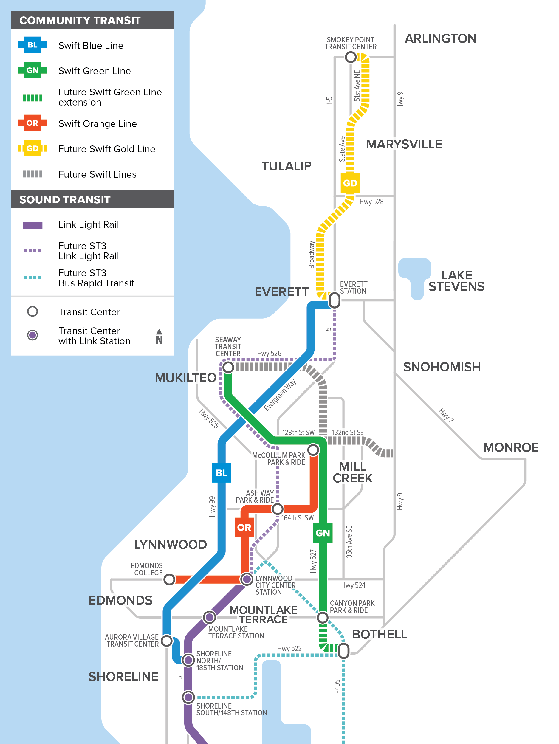 Map of Swift bus rapid transit network
Swift BRT is a proven, reliable, and popular travel option already established in Snohomish County. Swift Gold Line will bring this same level of service to north Snohomish County.
No matter how you get around, Swift Gold Line benefits everyone with:
- Fast and frequent service with buses arriving every 10 minutes on weekdays and every 15-20 minutes during early mornings, evenings, and weekends.
- Expanded transit service requiring no additional local funding or new taxes.
- Access to more destinations in Snohomish County and new connections to get you farther on Community Transit buses, Link light rail, and other regional transit services.
- Service that can approach the speed, frequency, and reliability of light rail without billions in costs.
- Everyone who rides transit instead of driving is someone who doesn’t add to rising traffic and helps control carbon emissions.
- Stations and signs designed for your convenience, including rain shelters, lighting, seating, and digital signs with real-time information.
- Roadway improvements that benefit cars, buses, and pedestrians.
Stations
Proposed Station Locations
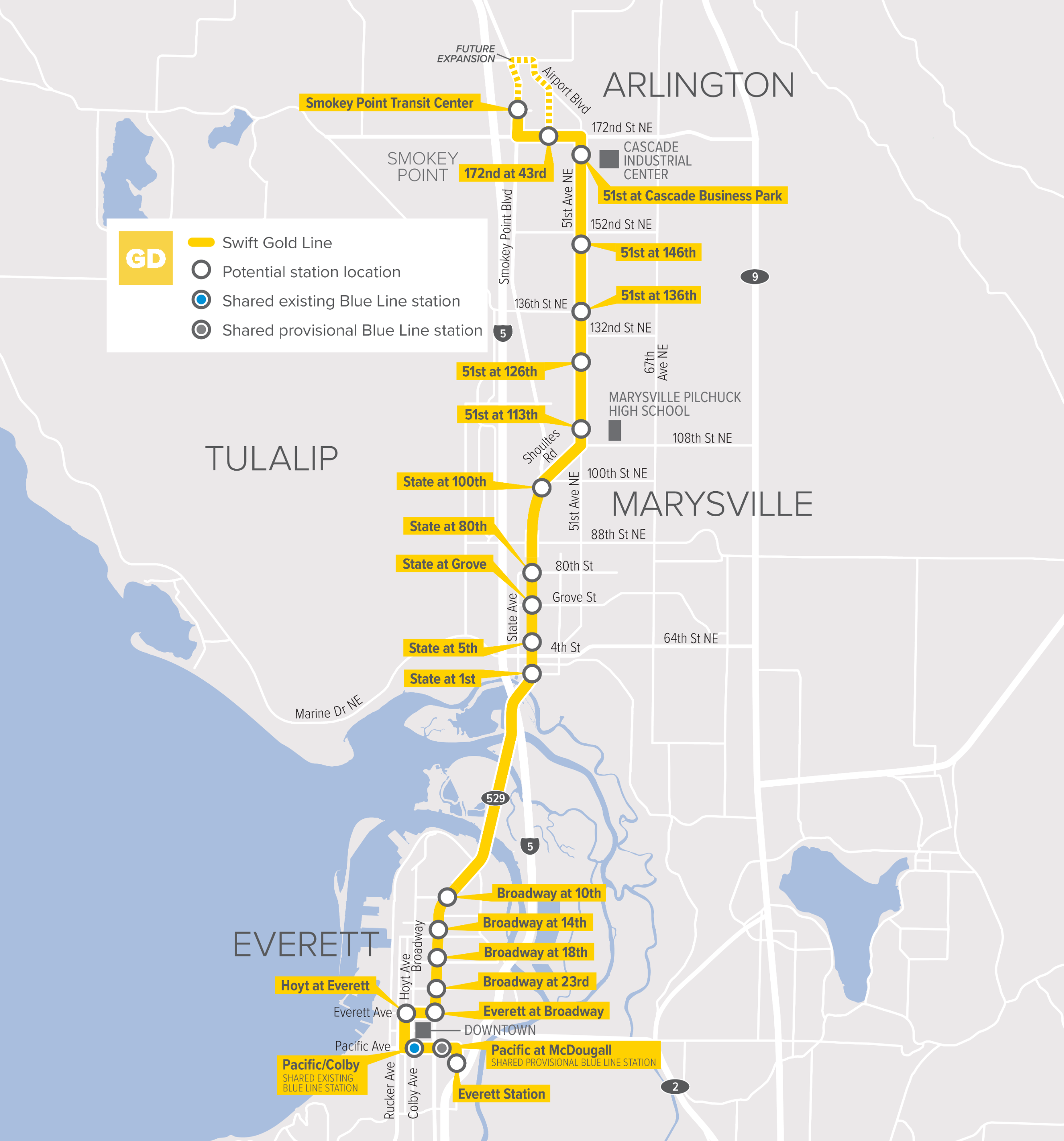
Map of Swift Gold Line route and proposed station locations
Swift Gold Line proposes to add:
- 17 new station pairs, including:
- Hoyt Ave at Everett Ave
- Everett Ave at Broadway
- Broadway at:
- 23rd St
- 18th St
- 14th St
- 10th St
- State Ave at:
- 1st St
- 5th St
- Grove St
- 80th St NE
- 100th St NE
- 51st at:
- 113th Pl NE
- 126th Pl NE
- 136th St NE
- 146th St NE
- Cascade Business Park
- 172nd St NE at 43rd Ave NE
- New stations at both Smokey Point Transit Center and Everett Station
- Access to Swift Gold Line at the existing Pacific/Colby Swift Blue Line station
- Future consideration for a new station pair to be shared for Swift Gold Line and Swift Blue Line on Pacific Ave at McDougall to serve the future outdoor event center, pending the location of the Sound Transit Everett Link Extension light rail station.
As part of this project, you’ll see changes at Everett Station and Smokey Point Transit Center. Right now, we’re designing changes at these two locations, which include:
- Everett Station: Everett Station is an active transit center and we need to make some adjustments to accommodate Swift Gold Line, in addition to the existing Swift Blue Line. We will:
- Add a new Swift station
- Add space for buses to take breaks (layover)
- Explore opportunities for adding charging for zero emissions buses
- Smokey Point Transit Center: With the addition of Zip Shuttle, increasing local bus service, and Swift Gold Line at Smokey Point Transit Center, we will:
- Add a station for Swift Gold Line
- Add space for buses to take breaks (layover)
- Add designated locations for other services
- Expand the transit center to add new bus bays for local service
- Explore opportunities for adding charging for zero emissions buses
- Improve accessibility and pathways
Many factors go into determining proposed station locations. The project team evaluated:
- Community input from Phase 1 engagement, as well as comments received during the Long Range Planning process and through our Customer Care team.
- Projected ridership
- Construction costs
- Accessibility to key destinations
- Connections to other transit options
- Distance between stations to ensure the bus can move…swiftly
- Space (i.e., is there enough room for a station?)
The project team will consider input and make updates to station locations. You can provide input on the proposed station locations again in 2026.
In July 2024, you had the opportunity to provide input on three route options in Marysville: Options A, B, and C. Each route received both positive and negative comments. Option B was well received for the speed of north-south travel and for providing increased access to residential areas over Option A. Option B balances the community’s interest in travel time through the corridor as well as access to both residential and commercial areas.
Community Transit identified route Option B (pictured in the map above) as the preliminary route option for Swift Gold Line. Route Option B balances the community's needs with long-term efficiency, directness of travel, and ensuring the best outcome for future transit users.
In September 2025, you had the opportunity to provide input on the proposed station locations and three bus lane options: center-running transit-only lanes, business access transit (BAT) lanes, and curbside in mixed traffic with transit signal priority. We heard strong support for the proposed station locations and the use of center-running transit-only lanes, along with questions about parking, business impacts, and the removal of the two-way center-turn lane.
Read more in the Swift Gold Line Phase 2 Engagement Summary
BRT Design
Swift Gold Line will improve on the current Swift system and keep traffic moving safely for everyone.
Community Transit studied three options for where Swift Gold Line buses would travel on the roadway in high-traffic areas Everett and Marysville. Those options are:
- Center-running transit-only lanes: Center-running lanes that are dedicated for transit use only. One-lane, bi-directional, center-running transit-only lanes in Marysville and one- or two-lane center-running transit-only lanes in Everett where BRT buses are isolated from regular car traffic.
- Business Access Transit (BAT) lanes: BAT lanes are curbside lanes reserved for buses and cars making right turns.
- Curbside in mixed traffic with transit signal priority: Buses operate in the curbside lane with other traffic. This also includes changes to traffic signals to prioritize buses, called transit signal priority (TSP).
Outside of these areas in Everett and Marysville, BRT buses would use a combination of BAT lanes and curbside in mixed traffic with transit signal priority.
All of these options would use transit signal priority (TSP). TSP uses technology on buses to communicate with upcoming traffic signals. This gives the bus more green time, less red time, and results in improved traffic flow for buses and cars alike.
Careful analysis shows that the best design option for Swift Gold Line is to use center-running transit-only lanes in these areas of Everett and Marysville. Factors include:
- Trouble with mixed traffic: Traffic models show that when buses travel in curbside lanes with mixed traffic (cars and buses) or BAT lanes (cars turning right and buses), traffic will slow down and get worse, and bus travel times would only slightly improve.
- Impact on ridership and funding: If bus travel times don’t improve, models show that fewer people will ride. That would hurt the project’s chances of getting the federal funding needed to build it.
- Center-running transit-only lanes help everyone: Center-running transit-only lanes offer a solution that will benefit everyone with roadway improvements for cars, buses, and pedestrians. This option improves traffic flow by separating buses and cars, while maintaining the current number of vehicle through-lanes. Improved intersections and traffic signals in congested areas will benefit all traffic.
Bus lane option analysis
The analysis on the bus lane options for high-traffic areas of Everett and Marysville is summarized in the table below:
| Options | Center-Running Transit-Only Lanes* | BAT Lanes | Curbside in Mixed Traffic |
|---|---|---|---|
| Expected number of bus riders | High | High | Low |
| How competitive the project would be for federal funding that's needed for the project | Competitive | Competitive | Not Competitive |
| Time to travel through high-traffic areas of Everett and Marysville in a car | 1 minute saved | 4 - 7.5 minutes lost | 1 minute saved |
| Time to travel through high-traffic areas of Everett and Marysville on a bus | 3.5 – 4 minutes saved | 3 minutes saved | 0.5 – 1 minutes saved |
| How driving lanes would change | Removes 2-way turn lane | Removes 1 thru-traffic lane in each direction | No changes |
| Improvements to roadway/sidewalks | Substantial | Limited | Limited |
| Improvements to roadway safety | Substantial | Moderate | Limited |
| Expected local cost | $76 – $80M (40%) | $75M (40%) | $167M (90%) |
| Impacts to parking spaces on Broadway | 122 – 339 spaces lost | 40 spaces lost | 40 spaces lost |
*This summarizes the impacts for both one-lane and two-lane center-running transit-only lanes.
Click here for a PDF of this table with more details for Everett and Marysville.
More details about bus lane options
Click on the drop-downs below to learn more about each option.
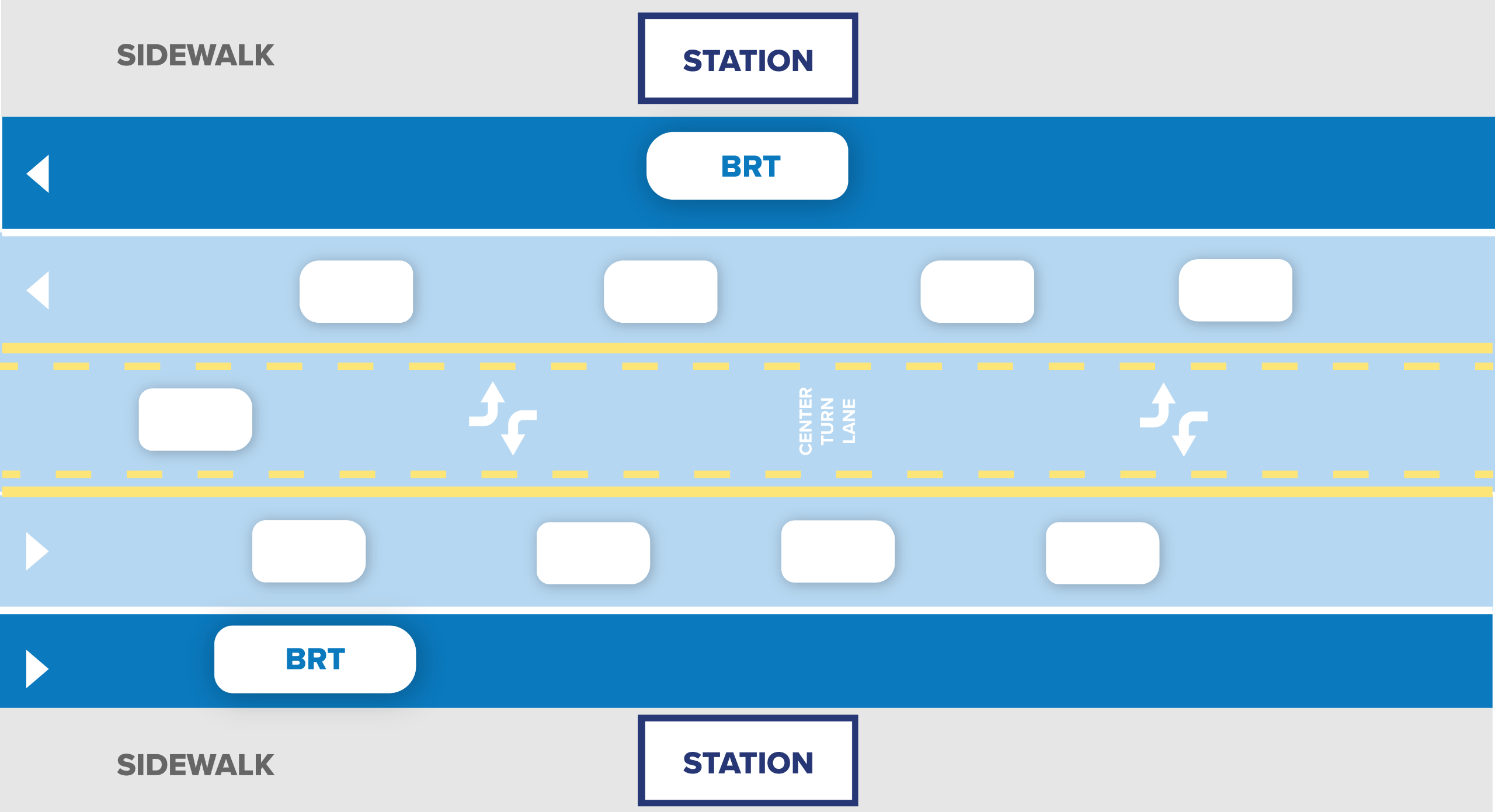
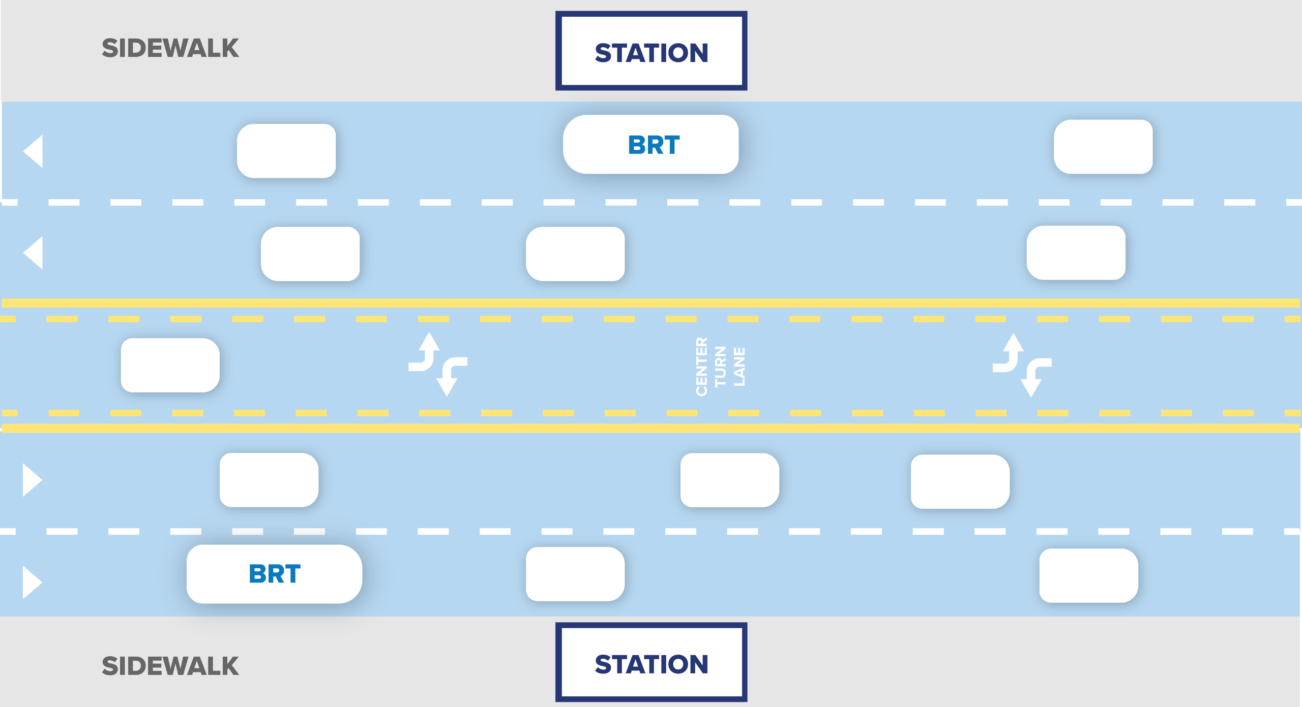
With center-running transit-only lanes, Swift buses would travel in a dedicated lane in the middle of the road for portions of the project in Everett along Broadway and Marysville along State Ave.
Approximate areas under consideration for center-running bus lanes
Based on analysis and modeling, center-running transit-only lanes are the best option for this project in the designated areas. These lanes provide the most benefit to everyone in the community. These lanes:
- Maintain the same number of through lanes for driving cars as there are today.
- Remove the two-way left turn lane to minimize property impacts, but maintains left-turn lanes at lights with an option to U-turn. This creates more predictable turns for drivers and improves safety for drivers and pedestrians.
- Offer even faster, safer, and more efficient BRT design, used around the world.
- Separate BRT buses from cars, so BRT buses don’t compete with cars in regular traffic lanes.
- Improve intersections and streets, making neighborhoods better for residents and businesses.
- Improve traffic flow for cars and buses compared to curbside in mixed traffic and dedicated lanes on the right (BAT lanes). Focus on improving traffic flow in areas where there are currently the most delays for buses and cars.
- Create the opportunity for high projected ridership, which means high favorability for receiving federal funding needed to complete the project.
- Highest cost to build the project when compared to the other options.
Watch this 2-minute video from That Transit Show to learn more about how center-running transit-only lanes work.
What is the alternative to dedicated, center-running lanes in these areas of Everett and Marysville?
The alternative to dedicated, center-running lanes in these areas is curbside in mixed traffic with transit signal priority (TSP), where BRT buses drive in the rightmost lane with regular car traffic. As population continues to increase and traffic continues to worsen, operating BRT buses in curbside in mixed traffic does not improve the flow of traffic for cars and buses.
There are two designs for center-running lanes under consideration for this project:
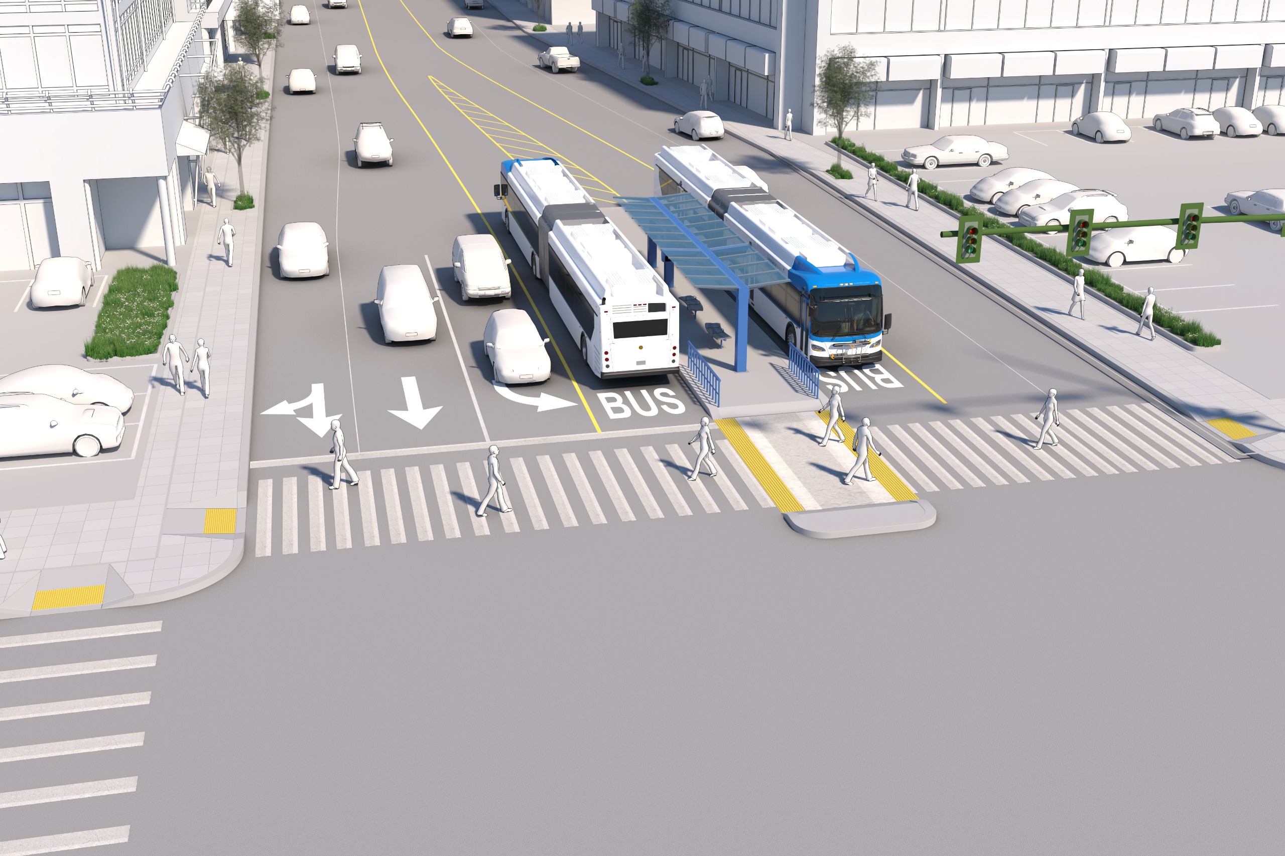
Two-Lane center-running transit-only lanes
Two-lane center-running transit-only lane station and roadway animation
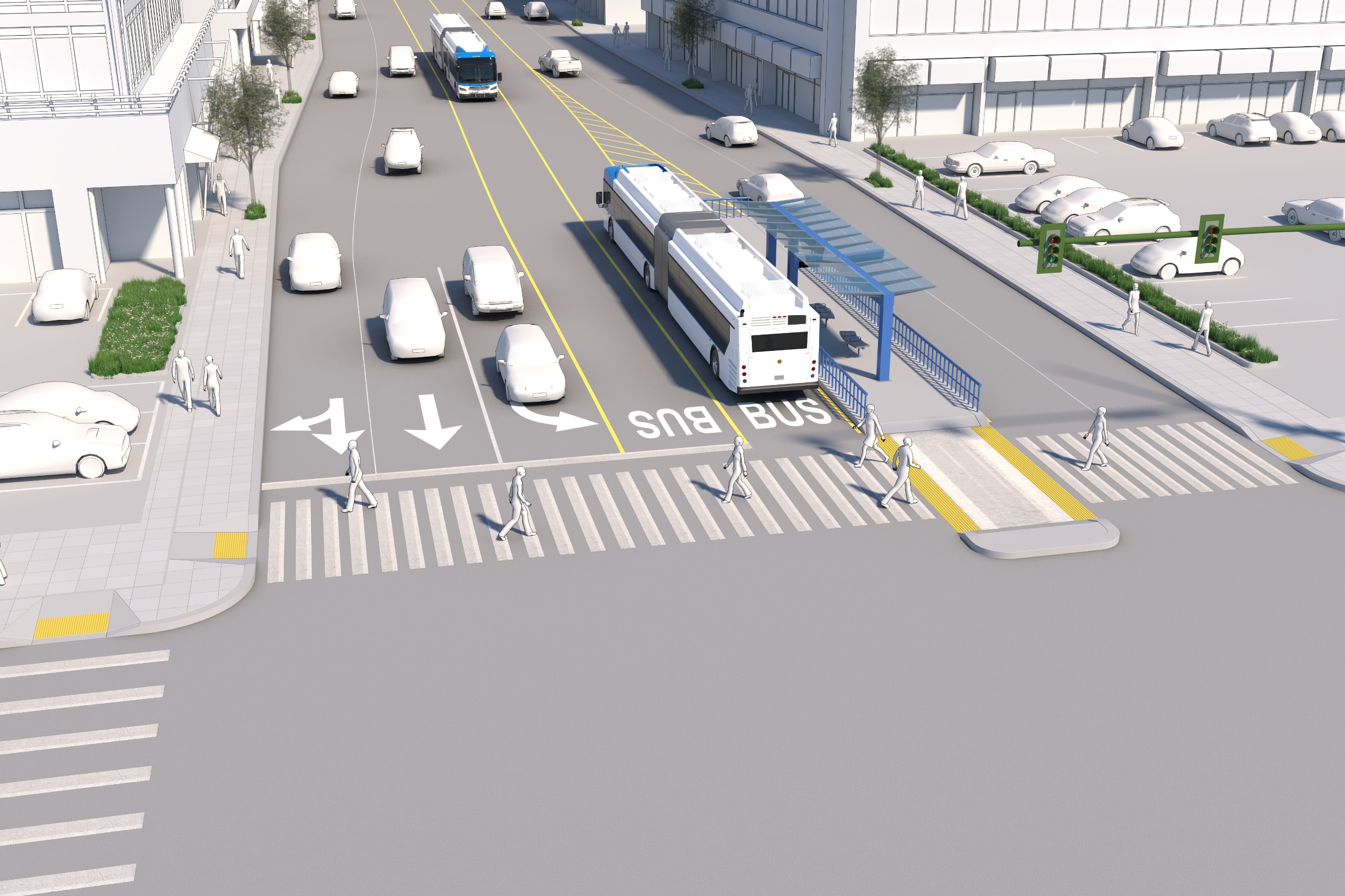
Two-lane center-running transit-only lane station access example
Two-lane center-running transit-only lanes are proposed on Broadway in Everett between Everett Ave and Tower St. This area could also use one-lane center-running transit-only lanes or curbside in mixed traffic, resulting in fewer benefits for everyone.
- Two separate lanes in the center of the road for buses to travel in both directions.
- Stations in the center of the roadway, one station for each direction, resulting in higher construction costs when compared to one-lane center-running lanes.
- Riders access stations via crosswalks. The stations also create places for people crossing to rest, if needed, increasing safety for people walking regardless of whether they are using transit.
- Requires more space to build stations with minimal impacts to existing businesses and residential properties if parking is repurposed.
- Maintains the same number of car travel lanes, but impacts on-street parking.
- Greatest improvement to traffic flow for cars and buses when compared to one-lane center-running and curbside in mixed traffic.
- Improves safety in the corridor with improved intersections and streets.
- Emergency vehicles can use the lanes, speeding up emergency responses and increasing public safety.
One-lane center-running transit-only lanes
One-lane center-running transit-only lane station access example
One-lane center-running transit-only lanes are proposed on State Ave in Marysville between approximately 1st St and 84th St NE, and 92nd St NE and 100th St NE. This area could also use curbside in mixed traffic, resulting in fewer benefits for everyone. One-lane center-running lanes are also an option for the area in Everett where two-lane center-running are proposed, but the benefits are not as great.
- Only one lane in the center of the road dedicated for BRT buses, shared by north- and southbound buses. Buses pass each other at stations or other predetermined locations.
- Stations are shared for both directions of travel, resulting in reduced costs for construction compared to two-lane center-running lanes.
- Riders access stations via crosswalks. The stations also create places for people crossing to rest, if needed, increasing safety for people walking regardless of whether they are using transit.
- Can be implemented in areas where there is limited space available.
- Maintains the same number of car travel lanes.
- Maintains the majority of on-street parking in Everett. There is currently no parking in Marysville on this corridor, so there are no impacts.
- Improvement to traffic flow for cars and buses, when compared to mixed traffic.
- Improves safety in the corridor with improved intersections and streets.
Business Access Transit (BAT) lanes change the rightmost lane into a right-turn only lane for cars. Buses can travel through intersections in this lane. This option is proposed for some segments along the corridor. BAT lanes are not an alternative for the proposed center-running lanes in high-traffic areas of Everett and Marysville described above due to impacts to traffic.
Two of the existing Swift lines (Swift Blue Line and Swift Green Line) use BAT lanes in select areas. BAT lanes are proposed for Swift Gold Line in some areas where it will improve traffic flow. The short distances between intersections on Broadway in Everett and State Ave in downtown Marysville make BAT lanes only minimally effective for improving traffic flow for buses and has negative impacts for car traffic.
- Removes one driving lane for through traffic in each direction.
- The right-lane of traffic becomes right-turn only, meaning buses get in the way of cars. Buses also get stuck behind cars turning right and travel more slowly due to traffic.
- High projected ridership similar to center-running transit-only lanes.
- Similar local cost when compared to center-running transit-only lanes. Lower local cost compared to curbside in mixed traffic.
- Opportunity to improve sidewalks and crossings, but fewer opportunities for roadway and safety improvements when compared to center-running transit-only lanes.
Business Access Transit (BAT) lane BRT station and roadway diagram
Curbside in mixed traffic is where buses travel in the rightmost lane along with general purpose traffic. This option is proposed for Arlington, north Marysville, and parts of Everett. It is also an alternative for key areas in Everett and Marysville where dedicated center-running lanes are proposed.
- Current Swift lines travel in the rightmost lane for most of their route.
- Changes at key intersections to improve speed and reliability for transit. Otherwise, no changes to the roadway.
- Can be implemented anywhere in the corridor, but buses get in the way of cars, slowing down traffic. Buses also get stuck behind cars turning right and travel more slowly due to traffic.
- Low projected ridership, which means low favorability for federal funding, which is necessary to complete the project.
- Highest local cost to build the project when compared to the other options due to low favorability for federal funding needed to complete the project.
- Opportunity to improve sidewalks and crossings, but fewer opportunities for roadway and safety improvements when compared to center-running transit-only lanes.
Curbside in mixed traffic BRT station and roadway diagram
Q&A
Have a question?
Submit it using this Q&A tool and someone from the project team will get back to you.
Please ask questions below and a member of our team will respond as soon as possible.
To ask a question you must create an account or log in.
These are the people that are listening and responding to your questions.

Swift Gold Line Project Team
{{question.description}}